Blog: Citizen Observatories adding value to the Copernicus Space component
The European Commission and the European Space Agency are jointly funding and supporting a massive investment program to implement and operate a complete Earth Observation program called Copernicus. Its purpose is to monitor the Earth for the next decades through both a space and an in-situ component, and the data will be distributed through the Copernicus services. A massive amount of data can be exploited by downstream services for multiple targeted public and private markets. 
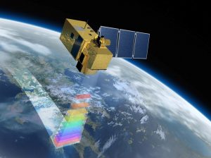
The Copernicus Space segment [1] is composed of a new family of satellites, the Sentinels. The first Sentinel-1A was launched in April 2014, providing all weather day and night radar images. Sentinels 1A, 2A, 2B, and 3A are operating above our heads at the moment, and have provided until now about 40 PetaBytes of data (1 PB = 1000 000 GB). The Copernicus Services also rely on environmental measurements collected by external data providers, including geospatial reference or ancillary data, referred to as “in-situ” data. The Copernicus in-situ component [2] maps the in-situ data availability, and identifies data access gaps. Both space and in situ data are contributing to the Global Earth Observation System of Systems (GEOSS), the worldwide initiatives to share, standardize and provide GEO data for environmental and exploitation purposes.
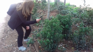
The GEOSS program is supporting Citizen Science and Citizen Observatory projects as potential in-situ data providers. The different EC funded Citizen Observatory projects can support the GEOSS initiative through the provision and the standardisation of citizen observation-based data. The Ground Truth 2.0 project is participating actively to the GEOSS initiatives by providing its citizen observations, and by leading debates and standardization activities.
When looking at the data itself, space and in situ components have their own specificities regarding spatial and temporal resolutions. Satellites are providing data with low spatial and temporal resolutions (from daily to fortnightly) but over a very large swath, allowing global or continental monitoring. On the contrary, in-situ components can provide data at a fine temporal resolution and precise location, but limited to single location information. So, the combination of both components is crucial for global and precise environmental monitoring. In addition, the space segment is providing radiometric data that require modelling to be translated to real physical information. The accuracy of the models can only be compared with Ground Truth data. This is where in situ information is crucial to support the Copernicus Space component.
Citizen Observatories such as those set up in Ground Truth 2.0 are supported by the European Commission as a way to provide the relevant information to calibrate and validate its Copernicus space segment at a relatively low cost compared to the budget of Copernicus. Citizen Observatories have a huge potential to bring information to the scientific community that will support the exploitation of satellites at the highest accuracy.
References:
[1] http://www.esa.int/Our_Activities/Observing_the_Earth/Copernicus/Overview3
[2] https://insitu.copernicus.eu/
This blogpost was written by Camille Pelloquin from Starlab.